Published on
January 1, 2026

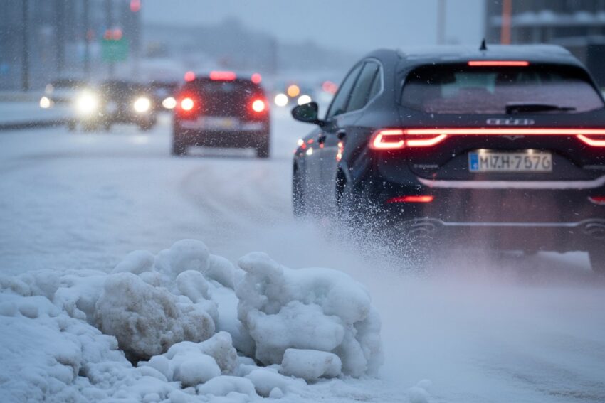
The United Kingdom has kicked off 2026 with a significant winter weather event, as the Met Office and other official authorities issue a series of amber and yellow weather warnings for snow and ice across large parts of the country. Travellers and residents are being urged to prepare for disruption to transport, travel, and daily life as Arctic air brings colder temperatures, snow showers and hazardous conditions throughout the first week of January.
This article explains the official weather warnings, the expected impacts on travel and public safety, and what UK citizens and visitors should consider when planning journeys during this cold spell.
What the Official Met Office Warnings Say
The UK’s national weather service, the Met Office, has issued National Severe Weather Warnings for snow, ice and cold weather as Arctic air grips the country. These warnings are classified as amber and yellow alerts depending on severity and expected impacts.
Amber warnings indicate an increased likelihood of significant impacts from the weather, including travel disruption and potential danger to life and property. Under this alert, people are advised to prepare and take action ahead of severe conditions.
Yellow warnings reflect a medium chance of impacts that could include delays on roads, icy pavements, and transport disruption, but with less severity than amber warnings.
Key takeaways from the latest official warnings:
- Amber snow warnings are in force for parts of northern and northeastern Scotland, with heavy snow showers expected to bring accumulations of 10–20 centimetres at lower levels and up to 40 centimetres on high ground between 2 and 3 January 2026. Windy conditions could result in drifting snow and temporary blizzard-like conditions.
- Yellow warnings for snow and ice cover much of England, Wales, Northern Ireland and central Scotland, with snow showers and ice forming on untreated surfaces.
- Snow and icy conditions are likely to persist through early January, with the risk of additional warnings if conditions change rapidly.
Expected Weather Conditions and Forecast
According to the Met Office five‑day forecast:
- Northern and eastern parts of the UK are already experiencing snow showers that could lead to significant accumulations, especially in the Scottish Highlands and other elevated locations.
- The cold snap will remain across much of the country through Friday and into the weekend, with frost and ice forming on roads, pavements and transport routes.
- Even areas that do not see heavy snow are likely to experience frost, freezing temperatures and slick surfaces, making travel more challenging than usual.
Temperatures in many regions are expected to remain well below average for this time of year and could continue to be cold into the first full week of January 2026.
What This Means for Travel and Transport
The official weather warnings have serious implications for travellers using UK roads, railways, airports and footpaths:
- Road travel is likely to be affected by snow and ice. Snow showers and icy patches may lead to slower journeys and longer travel times, particularly on untreated roads and rural routes.
- Public transport services — including buses, coaches and trains — could experience delays or cancellations due to snow on tracks, icy conditions around stations, and necessary safety measures.
- Air travel may be disrupted if snow impacts airport operations, runway treatments or access roads, especially for smaller regional UK airports.
- Pedestrian safety is a concern, with untreated pavements and cycle paths likely to become slippery, increasing the risk of slips and falls.
The Met Office enables travellers to check specific regional warnings via its official warnings portal, which details affected areas and expected impacts for snow, ice and other extreme weather situations.
Advice for Travellers and Residents
Both the Met Office and UK government agencies recommend practical steps to reduce risk and disruption:
- Check for travel updates before setting out, including road closures, public transport changes, and weather warnings for your route.
- Allow extra time for journeys and consider postponing non‑essential travel during periods of heavy snow and ice.
- Carry winter travel supplies if driving, such as warm clothing, food and water, a charged mobile phone, torch and vehicle essentials like an ice scraper.
- Stay on treated surfaces where possible and avoid walking on untreated pavements in icy conditions to reduce risk of injury.
Official guidance also encourages travellers to keep updated with the latest Met Office forecasts and national travel advice, as alerts can change quickly based on evolving weather patterns.
Public Health Considerations
In addition to transport impacts, the UK Health Security Agency (UKHSA) has issued amber cold health alerts for parts of England due to the expected extended cold spell. These alerts highlight increased risks to vulnerable individuals, particularly older adults and those with pre‑existing health conditions.
The agency warns that prolonged cold exposure can exacerbate conditions such as respiratory or cardiovascular illnesses and increase the risk of heart attacks, strokes and chest infections.
Summary Key Points
- Amber and yellow snow/ice warnings have been issued across the UK as Arctic air brings a cold start to 2026.
- Snow accumulations may reach 10–40cm in parts of Scotland, with lighter snow and ice elsewhere.
- Travel disruption on roads, public transport and potentially air travel is likely.
- Public safety and health risks increase during prolonged cold weather, particularly for vulnerable populations.
- People are advised to check travel plans, prepare for hazardous conditions, and take official warnings seriously