AccuWeather tropical experts are monitoring two areas closely for tropical development in the Atlantic Basin heading into mid-July.
In a setup similar to early July that led to the formation of Tropical Storm Chantal, a stalling front is expected to move towards the Southeast coast and into the warm waters of the Gulf which could be enough to generate tropical activity.
Tropical Storm Chantal which formed late on Independence Day formed in response to a stalled front and a weak dip in the jet stream. Chantal would later make landfall early on July 6 and brought heavy rain and flooding to parts of the Carolinas. Locations in North Carolina, such as Chapel Hill, received almost a month’s worth of rainfall in just one day.
AccuWeather.com
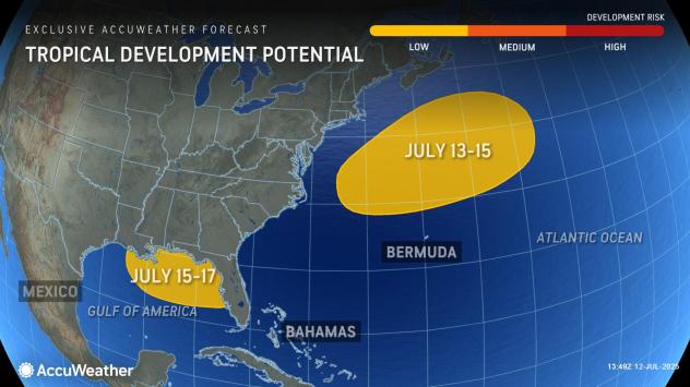
While the front is expected to be weak and the jet steam not as pronounced compared to the setup from earlier in the month, shear in the region is anticipated to be weaker. In turn, there is a low risk for tropical development from July 15-17.
Regardless of development, an increase in showers and thunderstorms can occur from the Carolinas into Florida and along parts of the Gulf coast which can lead to localized flooding. Rough surf and rip currents can also occur.
GET THE FREE ACCUWEATHER APP
Have the app? Unlock AccuWeather Alerts™ with Premium+

AccuWeather.com
AccuWeather tropical experts are also monitoring another low risk for tropical development north of Bermuda late this weekend into early next week.
“The same slow-moving cold front has the potential to lead to development north of Bermuda,” AccuWeather Lead Hurricane Expert Alex DaSilva said. “Sea-surface temperatures are cooler north of Bermuda and as a result anything that develops would likely be subtropical.”
Regardless of development, no impacts to land are expected.
Elsewhere across the Atlantic, the window for tropical activity through the middle of July will be closed. Vast areas of dust from the Sahara Desert as well as disruptive winds will be the main factors inhibiting any additional areas of development.

AccuWeather.com
The 2025 Atlantic Hurricane season has been off to a relatively fast start so far with three named storms. The historical average for formation of the third tropical storm is early August. Meanwhile, the average date for the first hurricane is Aug. 11.
The next name on the list is Dexter. The average date for the fourth named storm is Aug. 15, meaning an additional storm would set this season a month ahead of average.
AccuWeather Forecast Intern Julia Angerman contributed content to this article.
Want next-level safety, ad-free? Unlock advanced, hyperlocal severe weather alerts when you subscribe to Premium+ on the AccuWeather app. AccuWeather Alerts™ are prompted by our expert meteorologists who monitor and analyze dangerous weather risks 24/7 to keep you and your family safer.

