The National Hurricane Center is tracking three areas of interest in the eastern Atlantic for possible development.This is in addition to Hurricane Erin, which is anticipated to remain offshore of the Eastern U.S. coast. Leeward Islands A tropical wave located a few hundred miles east of the Leeward Islands is showing increased shower and storm activity. Conditions appear conducive for development, and a tropical depression is likely to form this weekend.Formation chance through 48 hours: 40%Formation chance through 7 days: 70% Eastern Tropical Atlantic – Invest 99-LInvest 99-L is producing showers and storms several hundred miles west-southwest of the Cabo Verde Islands and is starting to show some signs of organization. Recent satellite-derived wind data depict that the system does not have a well-defined center and therefore is not a tropical depression yet. Conditions appear marginally favorable for additional development in the next day or two, and it could become a short-lived tropical depression. By the end of the week, conditions appear unfavorable for further development.Formation chance through 48 hours: 40%Formation chance through 7 days: 40% Central AtlanticThe NHC tagged a small area of low pressure in the Atlantic. It is currently located 1,200 miles southwest of the Azores and producing limited showers and thunderstorms. Formation chance through 48 hours: 30%Formation chance through 7 days: 30%Hurricane Erin Hurricane Erin is beginning to pull away from the North Carolina coast on Thursday morning. Erin is forecast to remain at this intensity through Friday morning before weakening to a Category 1 storm as it moves into the northern Atlantic.Beachgoers should follow the guidance of lifeguards and any beach warning flags. Hurricane season 2025The Atlantic hurricane season runs from June 1 through Nov. 30. Stay with WESH 2 online and on air for the most accurate Central Florida weather forecast.>> More: 2025 Hurricane Survival GuideThe First Warning Weather team includes First Warning Chief Meteorologist Tony Mainolfi, Eric Burris, Kellianne Klass, Marquise Meda and Cam Tran.>> 2025 hurricane season | WESH long-range forecast
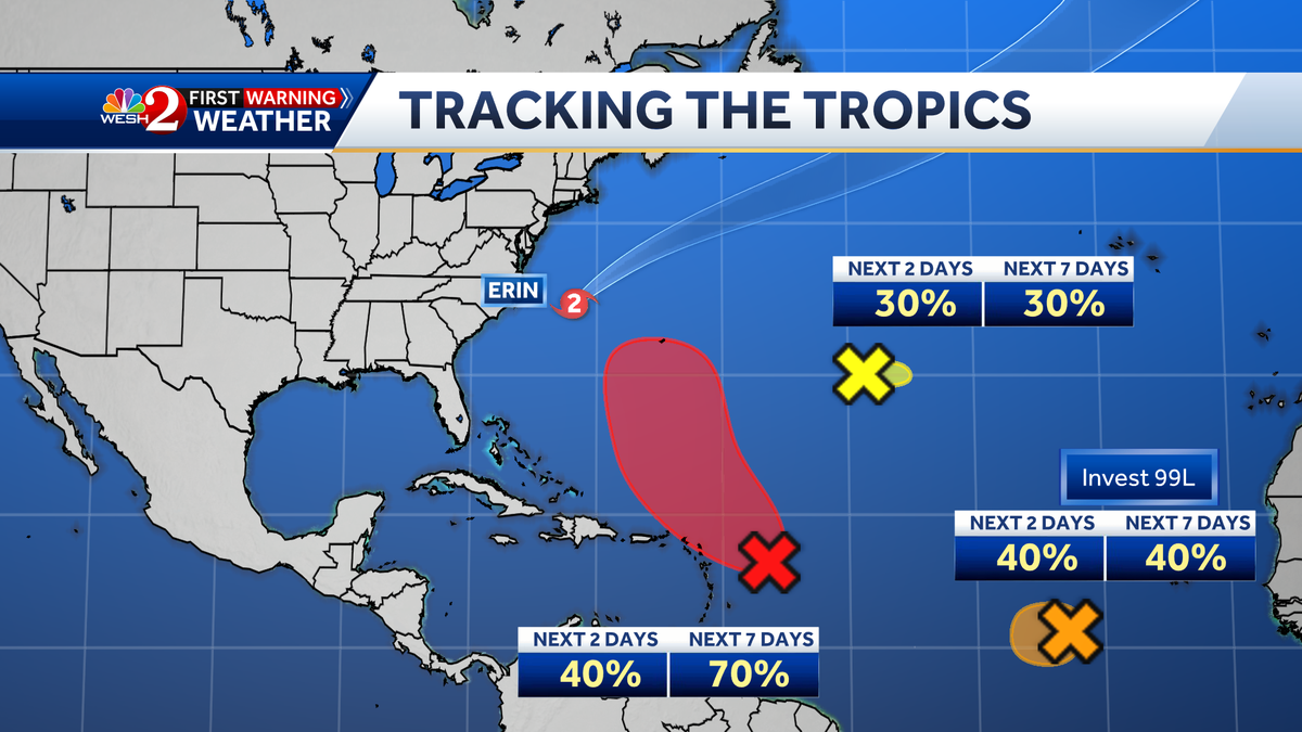
The National Hurricane Center is tracking three areas of interest in the eastern Atlantic for possible development.
This is in addition to Hurricane Erin, which is anticipated to remain offshore of the Eastern U.S. coast.
Leeward Islands
A tropical wave located a few hundred miles east of the Leeward Islands is showing increased shower and storm activity.
Conditions appear conducive for development, and a tropical depression is likely to form this weekend.
Formation chance through 48 hours: 40%
Formation chance through 7 days: 70%
Eastern Tropical Atlantic – Invest 99-L
Invest 99-L is producing showers and storms several hundred miles west-southwest of the Cabo Verde Islands and is starting to show some signs of organization.
Recent satellite-derived wind data depict that the system does not have a well-defined center and therefore is not a tropical depression yet.
Conditions appear marginally favorable for additional development in the next day or two, and it could become a short-lived tropical depression.
By the end of the week, conditions appear unfavorable for further development.
Formation chance through 48 hours: 40%
Formation chance through 7 days: 40%
Central Atlantic
The NHC tagged a small area of low pressure in the Atlantic. It is currently located 1,200 miles southwest of the Azores and producing limited showers and thunderstorms.
Formation chance through 48 hours: 30%
Formation chance through 7 days: 30%
Hurricane Erin
Hurricane Erin is beginning to pull away from the North Carolina coast on Thursday morning.
Erin is forecast to remain at this intensity through Friday morning before weakening to a Category 1 storm as it moves into the northern Atlantic.
Beachgoers should follow the guidance of lifeguards and any beach warning flags.
Hurricane season 2025
The Atlantic hurricane season runs from June 1 through Nov. 30. Stay with WESH 2 online and on air for the most accurate Central Florida weather forecast.
>> More: 2025 Hurricane Survival Guide
The First Warning Weather team includes First Warning Chief Meteorologist Tony Mainolfi, Eric Burris, Kellianne Klass, Marquise Meda and Cam Tran.
>> 2025 hurricane season | WESH long-range forecast

