BREAKING: Met Office issues rare red weather warning
A weather warning for wind in parts of south-west England has been upgraded to red between 4pm and 11pm.
“Storm Goretti will bring dangerous stormy winds for a time on Thursday evening,” the Met Office said.
“Dangerous” winds of up to 100mph are expected.
Bryony Gooch8 January 2026 14:07
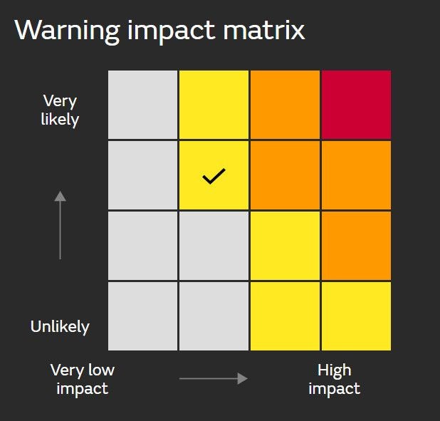
The Met Office warning system: what do the different colours mean?
Yellow Warning: Yellow warnings can be issued for a range of weather situations, according to the Met Office. Many are issued when it is likely that the weather will cause some low level impacts, including some disruption to travel in a few places. Many people may be able to continue with their daily routine, but there will be some that will be directly impacted and so it is important to assess if you could be affected.
Other yellow warnings are issued when the weather could bring much more severe impacts to the majority of people but the certainty of those impacts occurring is much lower. It is important to read the content of yellow warnings to determine which weather situation is being covered by the yellow warning.
Amber Warning: There is an increased likelihood of impacts from severe weather, which could potentially disrupt your plans. This means there is the possibility of travel delays, road and rail closures, power cuts and the potential risk to life and property, the Met Office said.
You should think about changing your plans and taking action to protect yourself and your property. You may want to consider the impact of the weather on your family and your community and whether there is anything you need to do ahead of the severe weather to minimise the impact.
Red Warning: Dangerous weather is expected and, if you haven’t already done so, you should take action now to keep yourself and others safe from the impact of the severe weather.
It is very likely that there will be a risk to life, with substantial disruption to travel, energy supplies and possibly widespread damage to property and infrastructure, according to the Met Office. You should avoid travelling, where possible, and follow the advice of the emergency services and local authorities.
Bryony Gooch8 January 2026 15:45
Emergency alerts sent as red weather warning issued
Emergency alerts have been sent as the Met Office has issued a red weather warning for the Isles of Scilly and Cornwall.
A Cabinet Office spokesperson said: “The Met Office has issued a red warning for the Isles of Scilly and Cornwall from 4pm to 11pm on Thursday 8th January.
“In light of the damaging winds and associated disruption, the Cabinet Office is issuing two Emergency Alerts to people in affected areas. The first was sent at approximately 3pm on Thursday 8th January to people in the Isles of Scilly. The second will be sent at approximately 5pm on Thursday 8th January to people in Cornwall.
“The Emergency Alert system will send a message to every compatible mobile phone in the impacted areas, containing information about the red warning and guidance on how to stay safe.
“Compatible mobile phones will make a loud siren-like sound even if they are set on silent. The sound and vibration will last for about 10 seconds.
“The UK Government has well rehearsed plans in place for severe winter weather and is working with teams from local authorities, the emergency services, and other public bodies to coordinate the response to any disruption.”
Bryony Gooch8 January 2026 15:34
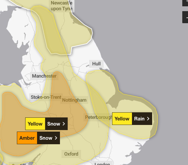
Mapped: What weather warnings are impacting the rest of England?
Amber snow warning across the Midlands, Wales, Yorkshire and Gloucestershire: From 8pm today until 9am tomorrow, rain associated with Storm Goretti will turn readily to heavy snow. Accumulations of 10-15 cm are likely fairly widely, with the potential for 20-30 cm in some locations, mainly on hills above 200 m elevation, more especially in Wales and/or the Peak District.
Yellow snow warning in the Midlands, the East of England, South East England, the North of England, the South West of England and Wales: From 5pm today until midday tomorrow, Storm Goretti is expected to bring heavy snow. Whilst not all areas may see accumulating snow, accumulations of 5-10 cm are likely quite widely, with scope for 15-25 cm in places, especially on some hills above 200 metres elevation. There is a chance of 30 cm accumulating over high ground in Wales and/or the Peak District.
Yellow rain warning in Yorkshire and the East of England: From 6pm today until 9pm tomorrow, heavy and persistent rain may lead to some flooding and disruption. 20-30 mm rainfall is likely quite widely, with a small chance of 40-60 mm in a few places, and strong winds, especially near coasts, will be an additional hazard with winds gusting 40-50 mph at times and leading to large waves through Friday.
Bryony Gooch8 January 2026 15:30
Rail closures now in effect in Wales – as Avanti West Coast cuts trains
Travel correspondent Simon Calder reports:
Transport for Wales says six railway lines will be closed completely from 3pm on Thursday, with a reduced service on the remainder. The standard advice from TfW is: “You cannot travel – there are no trains running and we are unable to run rail replacement bus services.”
The closed lines include the Heart of Wales line and all services west of Carmarthen.
The effect is being felt outside the nation: Transport for Wales runs trains between Liverpool and Chester, and has cancelled all services. “Network Rail have reported weather warnings for heavy sleet and snow in the area and have closed the railway to all services after 3pm, says TfW.
Avanti West Coast has started cancelling trains across its network – removing one of the three trains each hour between London Euston and each of Birmingham New Street and Manchester Piccadilly.
Bryony Gooch8 January 2026 15:30
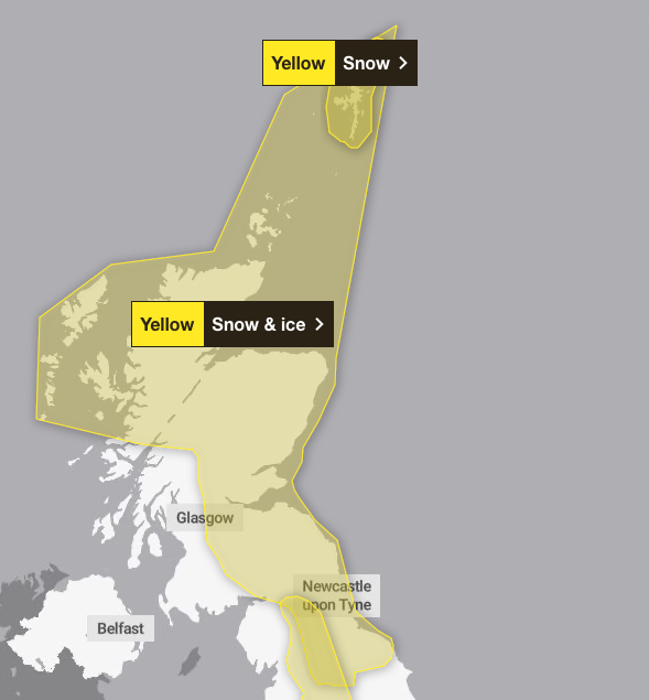
Mapped: What weather warnings are impacting Scotland and the north of England:
Yellow snow warning in the Shetland Islands: Between 4pm and 8pm today, outbreaks of sleet and snow are expected to become heavy at times this afternoon and early evening. Accumulations of 1 to 3cm are expected at low levels with 5 to 10cm over the hills.
Yellow snow and ice warning in Scotland and the north of England: From 8pm today until midday tomorrow, ice is expected to form widely again as surfaces refreeze through the evening and overnight. Scattered wintry showers will move inland across parts of northern England and eastern Scotland this evening and overnight into Friday. Showers may lead to some further modest snow accumulations of a few cms inland and over higher ground.
Bryony Gooch8 January 2026 15:23
Weekend weather forecast
Storm Goretti’s influence will wane on Friday evening as the system moves to the east of England. There will be a short-lived interlude of calmer weather for many on Saturday with rain showers easing, cloud for those in the east, and sunny spells possible elsewhere.
However, by Sunday further unsettled weather will move in from the west. As milder Atlantic air tries to displace the cold air over the UK it brings a risk of some further widespread snowfall and strong winds in the north of the UK and rain further south. There is still some uncertainty in the detail for the second part of the weekend so it’s important to stay up to date with the forecast.
The current outlook for next week is for the milder air to push across the UK, ending this current spell of cold weather and opening the door to temperatures closer to average for the time of year as well as further areas of low pressure bringing wet and windy spells from the west.
Bryony Gooch8 January 2026 15:15
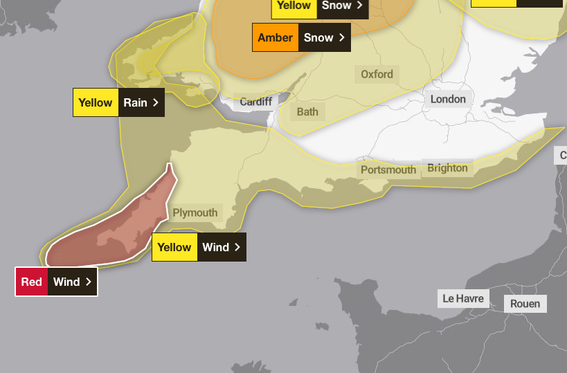
Mapped: What weather alerts are affecting the south west of England?
Red wind warning for Cornwall and Isles of Scilly: From 4pm until 11pm today, Storm Goretti will bring a period of exceptionally strong northwesterly winds to the Isles of Scilly and parts of Cornwall on Thursday evening, with peak gusts of 80-100 mph or more in exposed areas. Winds are expected to increase rapidly from 30-40 mph with violent gusts that may persist for 2-3 hours before easing. Winds will remain strong with the broader yellow warning in force until Friday morning.
Yellow rain warning in Wales: From midday today until 10am tomorrow, Storm Goretti will bring a spell of heavy rain and hill snow. Rain accumulations of 20-40 mm are possible, with perhaps as much as 60 mm in a few places. This, combined with snow melt, may lead to some surface water flooding.
Yellow wind warning in the south east and south west of England and Pembrokeshire: From 3pm today until 6am tomorrow, Storm Goretti will bring a spell of strong winds with peak gusts of 50-60 mph likely fairly widely, and 60-70 mph along exposed coasts and hills. Winds will gradually ease through the early hours of Friday.
Bryony Gooch8 January 2026 15:03
Red weather warning will bring ‘significant disruption’ says Met Office chief forecaster
Met Office chief forecaster Neil Armstrong has said that the “multi-hazard event” will bring significant disruption to many as a red “severe” weather warning has been issued.
“A Red severe weather warning for wind has been issued for the Isles of Scilly and much of Cornwall. Storm Goretti will bring exceptionally strong gusts in the Red warning area which could reach 100mph or more. Winds are expected to increase rapidly with violent gusts that may persist for 2-3 hours before easing. Heavy snow will affect Wales, the Midlands and parts of northern England overnight and through Friday morning. This multi-hazard event will bring significant disruption to many.
“Goretti will bring snow on its northern edge, this most likely over Wales and the Midlands. Here accumulations of 10-15 cm are likely widely, with 20-30 cm possible in some places, especially higher ground in Wales and the Peak District. An Amber warning has been issued where the greatest risk of disruption is likely on Thursday night into Friday morning. This is a complex spell of severe weather and I’d advise people in the warning areas to keep up to date with the forecast and messages from local authorities.”
Bryony Gooch8 January 2026 15:00
All trains from Cornwall to be suspended from 6pm
Network Rail said all trains in Cornwall will be suspended from 6pm on Thursday because of an amber weather warning for strong winds.
In Devon, trains on the Exeter-Okehampton and Exeter-Barnstaple routes will be suspended from the same time because of forecast high wind speeds.
Passengers are advised to travel earlier and not to attempt travel late this afternoon.
Services on affected routes are expected to be disrupted on Friday morning.
Replacement road transport will not be available as road conditions are also expected to be affected by the weather.
Bryony Gooch8 January 2026 14:56