Published on
February 13, 2026

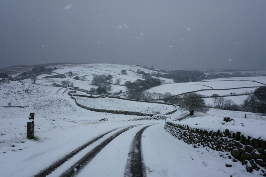
A snow and ice warning has been issued for parts of North Staffordshire, as the region braces for potential disruption due to the cold and wintry weather. The warning, announced by the Met Office, is in effect from 7:00 PM on Thursday, February 12, and is set to last until midday on Friday, February 13. The weather alert covers areas of the Staffordshire Moorlands, particularly affecting higher grounds such as Leek and surrounding areas. It’s expected to bring icy conditions and potentially hazardous travel disruptions.
Snow, Sleet, and Ice Expected to Impact Travel
The primary concern from the weather alert is the combination of rain, sleet, and snow, which will likely cause icy surfaces and make travel hazardous. Motorists and commuters are advised to be cautious, especially on higher routes where snow and ice accumulation could make roads slippery. The Met Office warns that these conditions may lead to some disruption in travel, particularly during the nighttime and early morning hours.
Tonight, as temperatures dip, rain in the area will transition to sleet and snow over higher terrain, especially above 300 meters in elevation. This shift in weather could create icy patches on roads, which will persist through the early hours of the morning. Temperatures are forecast to fall sharply, with the potential for freezing conditions. As snow accumulates on higher ground, more severe disruptions could be felt on the roads.
What to Expect from the Weather in the Coming Days
For those living in Stoke-on-Trent and surrounding areas, the weather will initially bring light snow around 1:00 AM on Friday. By 3:00 AM, the snow is expected to become heavier before turning into sleet around 6:00 AM. A period of light rain will follow, lasting through to the morning hours. For those in the Staffordshire Moorlands, the forecast suggests snow showers from late evening through the night, with the heaviest snow expected between 3:00 AM and 6:00 AM on Sunday. By Sunday, the snow will give way to light rain, although some snow may still fall at higher altitudes.
The BBC’s forecast for Stoke-on-Trent and the surrounding areas differs slightly from the Met Office predictions. According to the BBC, Stoke-on-Trent will experience sleet on Saturday night, transitioning into light rain by Sunday, with the cold temperatures persisting. In contrast, the BBC’s forecast for the Moorlands suggests that Leek will see snow late on Saturday, with snow showers continuing until 3:00 AM on Sunday, after which the conditions will change to sleet.
Accumulations and Impact on Higher Routes
One of the main concerns with this weather warning is the potential for significant snow accumulation, particularly at higher elevations. Snow is expected to fall heavily above 300 meters, with the highest areas, such as the hills around Leek, potentially seeing 2 to 3 centimeters of snow. In regions above 500 meters, as much as 5 centimeters of snow is possible, which could cause further travel disruption.
Advertisement
Advertisement
For those planning to travel through higher routes like the A53 Leek to Buxton road, the snow and ice could create dangerous driving conditions, especially in the early hours of the morning when visibility is reduced. The Met Office is urging drivers to prepare for icy patches and slow-moving traffic. Even lower areas may experience some snow accumulation, but it is expected to be minimal compared to the higher grounds.
What Should Residents and Travelers Do?
With snow and ice expected to affect travel conditions, the Met Office recommends several precautions to ensure safety during the adverse weather:
Advertisement
Advertisement
- Travel Disruptions: Those planning to drive or use public transport should allow extra time for their journeys, as icy roads and snowfall may cause delays. Higher routes could be particularly hazardous due to snow and ice accumulation.
- Road Safety: If you need to travel, make sure to drive slowly, especially on untreated roads. Keep your vehicle’s lights on and be mindful of icy patches on the roads. It is also advisable to carry essentials, such as a blanket, food, and water, in case of unexpected delays.
- Keep Warm: It is essential to stay warm during the cold weather, especially overnight. Be sure to have proper clothing and heating if you are staying at home. The cold weather can increase the risk of hypothermia, so it’s crucial to keep an eye on vulnerable family members and neighbors.
- Stay Updated: Keep an eye on the latest weather reports, as conditions can change rapidly. The Met Office and other official sources will provide regular updates, so stay informed about any further warnings or changes to the forecast.
Conclusion
North Staffordshire is facing challenging weather conditions over the coming days, with snow, sleet, and ice likely to cause disruptions in travel and daily routines. Residents, commuters, and travelers should prepare for these conditions by taking necessary precautions, particularly in higher regions where snow accumulation could lead to significant travel delays. By staying informed and exercising caution, the risks associated with the adverse weather can be minimized.