NEW YORK – A powerful Nor’easter spinning off the East Coast is now taking aim at the New York region, bringing a dangerous mix of heavy rain, powerful winds and coastal flooding. The storm, which battered the Carolinas earlier Saturday, will intensify overnight as it tracks north along the Atlantic Seaboard.
According to FOX Weather, the slow-moving system is impacting tens of millions from the Carolinas to Maine and could linger through midweek, disrupting travel and triggering power outages in major cities including Washington, D.C., Philadelphia and New York City.
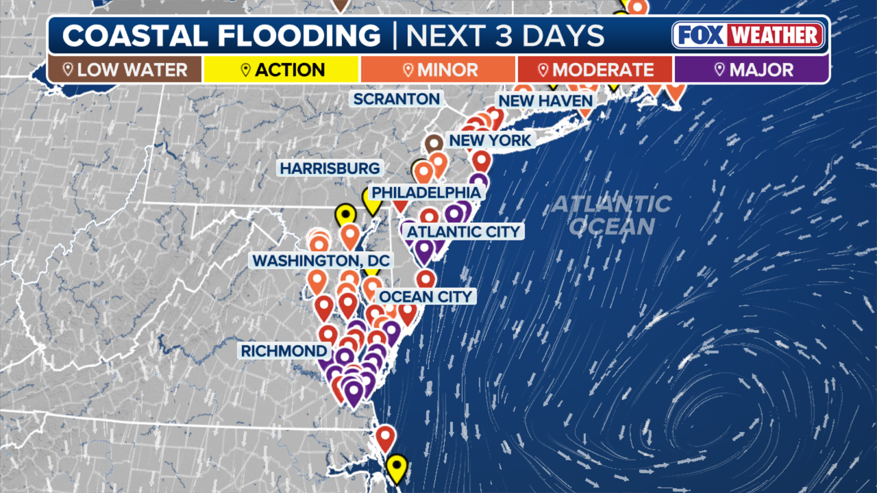
Northeast coastal flood threats through Monday. (FOX Weather)
Nor’easter latest
Saturday night: Conditions deteriorate
Light rain moved into the city Saturday afternoon, but heavier bands will arrive after dark as the storm strengthens. Winds will pick up quickly, with gusts increasing to 40 mph by midnight and even higher along the coast. The National Weather Service has issued Coastal Flood Alerts for the city, western Long Island Sound and southern Nassau County, where high tides may run 1–2 feet above normal.
Acting New Jersey Gov. Tahesha Way declared the state would enter a state of emergency at 10 p.m. on Saturday.
“Starting on Sunday, a dangerous coastal storm will begin to move past our state with extreme weather conditions for several counties, especially those on the Shore,” Way said. “In preparation for this storm, I am issuing a State of Emergency for all 21 counties out of an abundance of caution, authorizing our state’s emergency services personnel to activate as necessary. I urge all New Jerseyans to exercise caution, monitor local weather forecasts and warnings, stay informed on evacuation protocols, and remain off the roads unless absolutely necessary.”
Sunday: Peak impacts across New York City and Long Island
The storm will be at full force Sunday, bringing periods of heavy rain and gusts up to 60 mph in coastal areas. That combination could lead to scattered power outages, flooding on low-lying roads and travel delays across the region. FOX Weather meteorologists warn that water could pile up in New York Harbor, Jamaica Bay and along the South Shore, with the potential for beach erosion and minor structural flooding.
Rainfall totals could reach 2–4 inches in the city and higher amounts in the suburbs, with flash flooding possible in poor-drainage areas. Air travelers should prepare for significant delays at JFK, LaGuardia and Newark.

Monday: Slow improvement, lingering winds
The Nor’easter will weaken and move off the New England coast Monday, but gusty winds and spotty showers will linger. Commuters should expect a damp, breezy start to the workweek before calmer, cooler weather arrives midweek.
What you can do:
New Yorkers are urged to secure outdoor items, avoid coastal roads during high tide, and stay updated on the latest alerts. FOX Weather reports that while coastal flooding will peak Sunday, elevated tides and rough surf may persist into Monday before the storm fully pulls away.
The Source: Information in this story is from FOX LOCAL meteorologists and FOX Weather’s latest report on the Nor’easter impacting the Carolinas, Mid-Atlantic and Northeast.