Happy Saturday, everyone!
Make sure to enjoy the “warmer” temperatures today and tonight while they last. We have arctic air on the way that will make temperatures plummet starting Sunday night. Temperatures will remain BELOW FREEZING between Sunday night and Tuesday night – this includes both high and low temperatures.
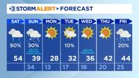
The high today will be 54 with mostly cloudy skies. Heavier and more widespread rain showers will continue until noon, and there will be additional spotty showers in the evening hours. About half an inch to three quarters of an inch of rainfall is expected by the end of the day. It is also very foggy this morning which will reduce visibility. Use caution if you have a commute. The fog is expected to linger throughout the day especially in the mountains. Winds have already picked up, and gusts will get up to 25 mph with sustained winds up to 15 mph. This will make it feel about five degrees colder than the actual temperature until temperatures warm up this afternoon. Roads will be slick due to the rain.
Tonight will be cold at 34 for the low with mostly cloudy skies. Roads will be slicker in higher elevations and areas below freezing. Spotty rain showers will eventually transition into chances for flurries Sunday morning. The northern Cumberland Plateau may receive a few tenths of an inch of snow, and the East Tennessee Mountains can expect about 2-3”. The rest of the Tennessee Valley will not have accumulation expected. The majority of the snow is remaining far north of Tennessee.
Sunday night is when temperatures are going to be riskier. The low will be 13 with a wind chill anywhere between -5 to 5 degrees. While the wind chill for us is technically not as dangerous as if we were at -20, it is still important to take necessary precautions for frostbite and hypothermia if you have to be outdoors. It is best to stay indoors overnight. Check on your people, pets, pipes, and plants.
The more dangerous wind chills will be for those who live in higher elevations. Wind chills may get -15 or lower.
We will continue to keep everyone updated with the latest forecast. Thank you, and please stay warm!