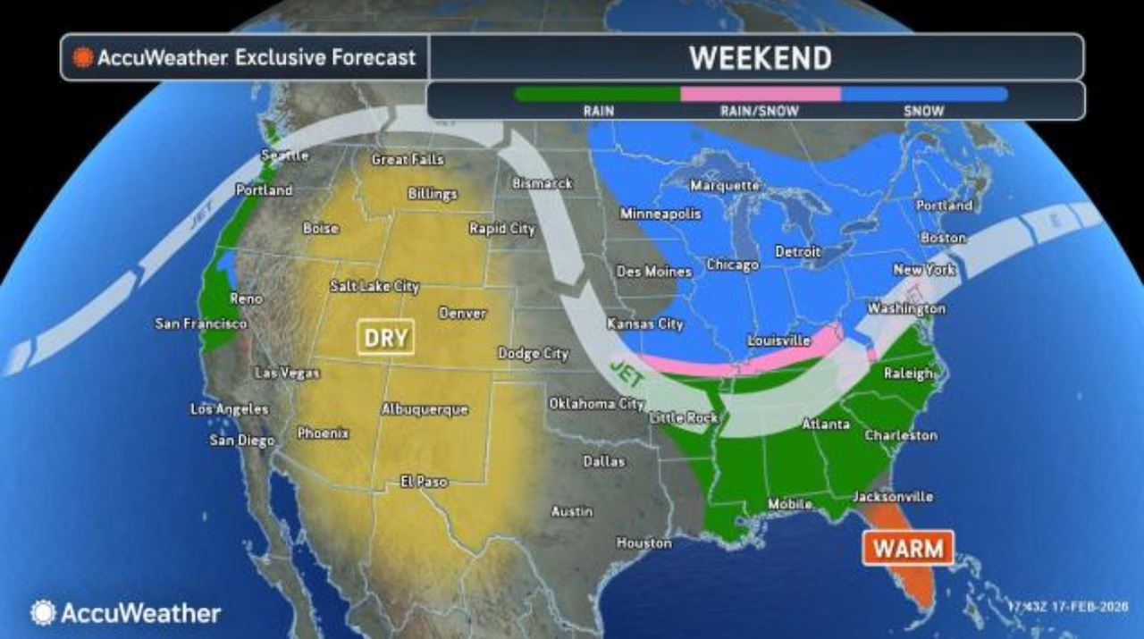
Weather forecasters say there’s a possibility of a “significant winter storm” developing off the Mid-Atlantic coast this weekend, and it could impact New Jersey.
However, the National Weather Service and AccuWeather both stress it is far too early to determine if our region will get hit with snow, rain, mixed precipitation or even nothing at all.
If the storm does develop and head in our direction, the precipitation would likely arrive on Sunday, forecasters said.
The weather service’s main forecast office in New Jersey said it could turn out to be a “significant winter storm” and there is a “potential for an accumulating widespread snowfall” in the Garden State.
However, big questions remain over the storm’s track and how much cold air will be in place if the storm does move into or close enough to New Jersey.
“The question, as always, is the track of the surface low,” the weather service said in its Tuesday afternoon forecast discussion. “There is still a chance the system shifts more southeastward and results in mostly a miss or a complete miss for our area.”
“The amount of cold air in place ahead of this storm and especially during it will be important when it comes down to precipitation types and amounts,” the agency added.
Forecasters from AccuWeather agree, saying “the situation is complicated and is not certain to bring snow to the big cities along the Interstate 95 corridor.”
AccuWeather said the storm is currently “off the coast of British Columbia in the eastern Pacific,” and it’s expected to move across California, “then swing across the Rockies on Friday, and then the Central states on Saturday.”
After that, some computer guidance models are suggesting the storm could move out into the Atlantic and strengthen into a strong coastal storm.
“There are a lot of pieces to the puzzle that would have to come together at the right time for a major storm to unfold and bring heavy snow late this weekend to early next week,” AccuWeather meteorologist Brandon Buckingham said.

Fog alerts issued in N.J.
More immediately, New Jersey drivers may have to contend with thick fog Tuesday night into Wednesday morning, followed by rain Wednesday afternoon and Wednesday night.
All 21 counties will be under a dense fog advisory from 10 p.m. Tuesday until 10 a.m. Wednesday because visibility on roads and highways may be reduced as low as a quarter-mile or a half-mile.
“Low visibility could make driving conditions hazardous,” the weather service noted. “If driving, slow down, use your headlights, and leave plenty of distance ahead of you.”
Forecasters said warm air and moisture near the ground will be passing over the lingering snow pack from recent snowstorms, creating the fog.
Low temperatures are expected to be in the low to mid-30s Tuesday night before rising into the low 40s on Wednesday.
Current weather radar