As Hurricane Milton approaches Florida, residents are being urged to heed evacuation orders and prepare for significant storm surges, high winds, and potential flooding.Hurricane Milton, which developed in the southwestern Gulf of Mexico, differs from previous hurricanes like Wilma in 2005. Unlike Wilma, which did not cause significant storm surge in Southwest Florida, this storm is expected to bring more severe impacts to the region.Watch live continuous coverage on NBC2. We will be on the southern side of the storm, which means winds will be blowing onshore. That’s why every storm is different. Even if the storm is farther away, we could still see significant impacts in terms of storm surge.The National Hurricane Center has issued storm surge forecasts of 6 to 10 feet for Charlotte Harbor and surrounding areas.Inland areas near water bodies like the Peace River are at higher risk, while locations farther from the coast, such as Babcock Ranch, are expected to be safer from the surge.Charlotte County has already issued evacuation orders for Zones A and B. The storm surge could reach up to 10 to 15 feet in areas north of Englewood, including Sarasota County, which is under evacuation for Zones A, B, and C.More: Know Your Zone Evacuation information and mapsThe peak surge is expected to occur late Wednesday afternoon and into Thursday morning as winds turn onshore. Winds could reach speeds of 100 to 110 mph in some areas, potentially causing widespread power outages and downed trees due to the region’s already saturated ground from a long, wet season.Where you park your car is important during a storm like this, Make sure you’re not parked under anything that could fall, like trees.In Lee County, including Cape Coral and Fort Myers, storm surge of 6 to 10 feet is expected along the coast, though inland areas such as downtown Fort Myers may see lower surge levels of 3 to 6 feet. Winds could reach 75 to 100 mph, with the highest gusts expected late Wednesday into Thursday morning.More: Shelters informationPower outages are likely across Lee County, and officials are warning of the potential for localized flooding with an additional 3 to 6 inches of rainfall.Collier County, including Naples and Marco Island, is not currently in the forecast cone but is still expected to experience storm surge of 4 to 7 feet along the coast and wind gusts up to 75 mph. Power outages and localized flooding are also a concern in this area.Farther inland, in Glades, Hendry, and Lake Okeechobee counties, storm surge is not expected to be an issue. However, these areas could still see rainfall totals of 1 to 3 inches and wind gusts up to 70 mph.As the storm continues to approach, residents are urged to follow local evacuation orders and prepare for potential disruptions. Watch live continuous coverage on NBC2. Go to our Hurricane Milton: What you need to know page for the latest updates.
As Hurricane Milton approaches Florida, residents are being urged to heed evacuation orders and prepare for significant storm surges, high winds, and potential flooding.
Hurricane Milton, which developed in the southwestern Gulf of Mexico, differs from previous hurricanes like Wilma in 2005. Unlike Wilma, which did not cause significant storm surge in Southwest Florida, this storm is expected to bring more severe impacts to the region.
Watch live continuous coverage on NBC2.
We will be on the southern side of the storm, which means winds will be blowing onshore. That’s why every storm is different. Even if the storm is farther away, we could still see significant impacts in terms of storm surge.
The National Hurricane Center has issued storm surge forecasts of 6 to 10 feet for Charlotte Harbor and surrounding areas.
Inland areas near water bodies like the Peace River are at higher risk, while locations farther from the coast, such as Babcock Ranch, are expected to be safer from the surge.
Charlotte County has already issued evacuation orders for Zones A and B. The storm surge could reach up to 10 to 15 feet in areas north of Englewood, including Sarasota County, which is under evacuation for Zones A, B, and C.
More: Know Your Zone Evacuation information and maps
The peak surge is expected to occur late Wednesday afternoon and into Thursday morning as winds turn onshore. Winds could reach speeds of 100 to 110 mph in some areas, potentially causing widespread power outages and downed trees due to the region’s already saturated ground from a long, wet season.
Where you park your car is important during a storm like this, Make sure you’re not parked under anything that could fall, like trees.
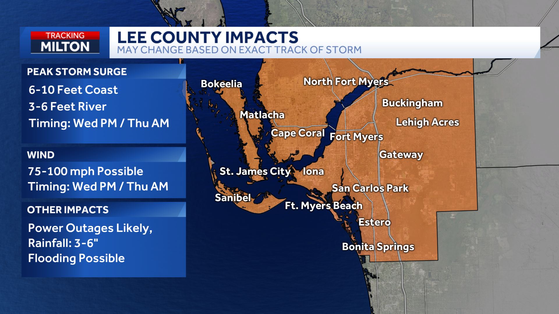
In Lee County, including Cape Coral and Fort Myers, storm surge of 6 to 10 feet is expected along the coast, though inland areas such as downtown Fort Myers may see lower surge levels of 3 to 6 feet. Winds could reach 75 to 100 mph, with the highest gusts expected late Wednesday into Thursday morning.
More: Shelters information
Power outages are likely across Lee County, and officials are warning of the potential for localized flooding with an additional 3 to 6 inches of rainfall.
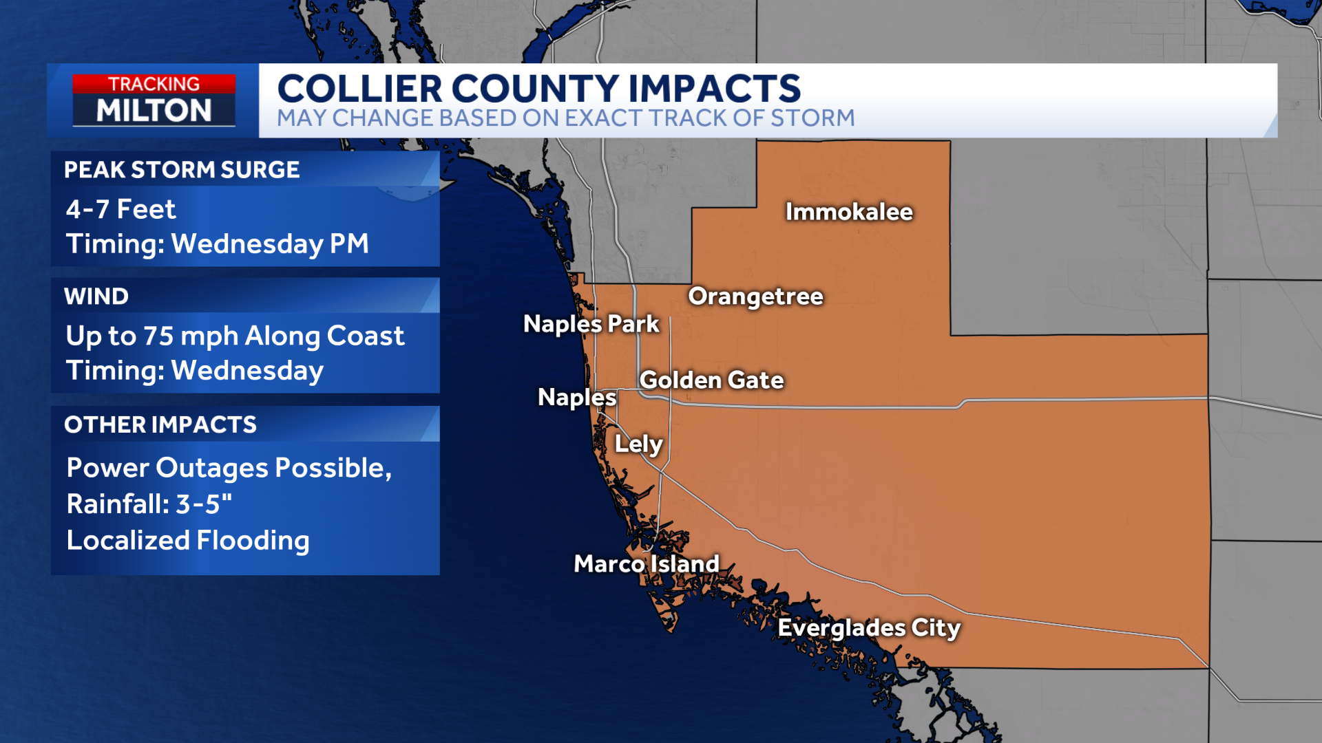
Collier County, including Naples and Marco Island, is not currently in the forecast cone but is still expected to experience storm surge of 4 to 7 feet along the coast and wind gusts up to 75 mph. Power outages and localized flooding are also a concern in this area.
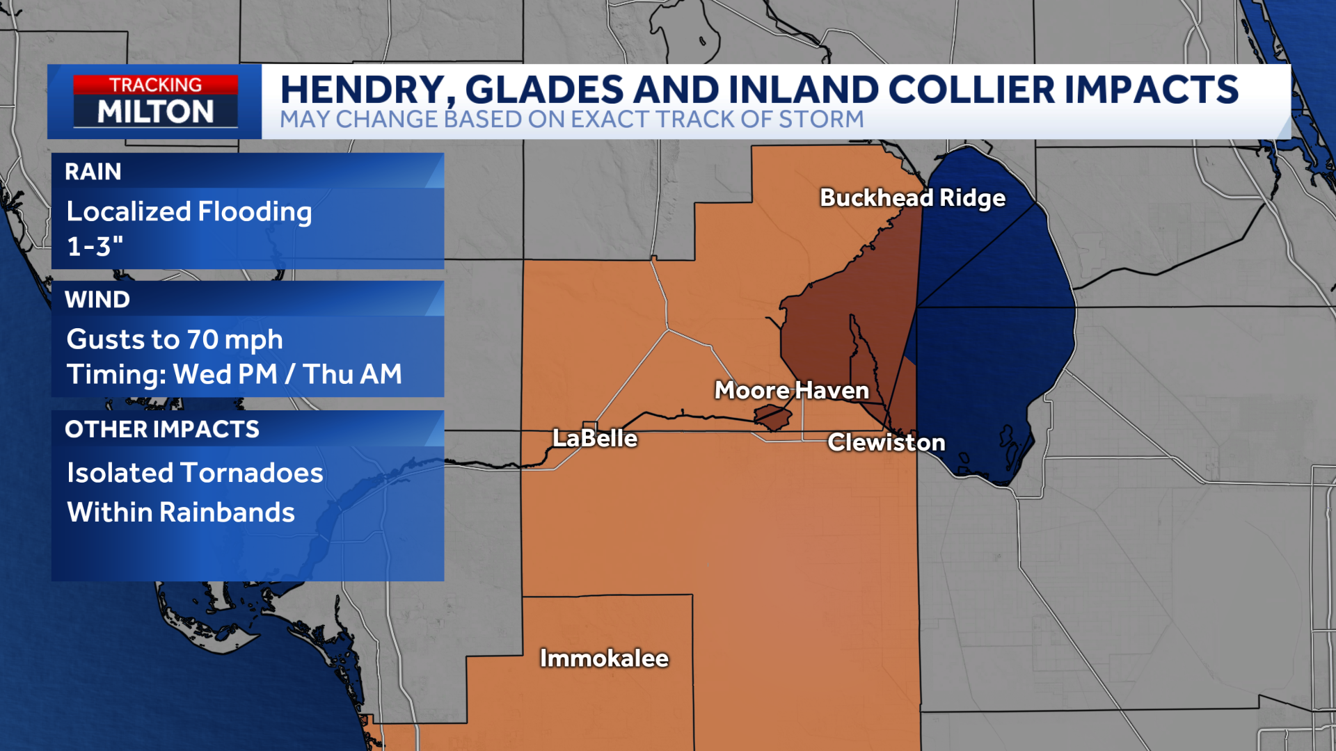
Farther inland, in Glades, Hendry, and Lake Okeechobee counties, storm surge is not expected to be an issue. However, these areas could still see rainfall totals of 1 to 3 inches and wind gusts up to 70 mph.
As the storm continues to approach, residents are urged to follow local evacuation orders and prepare for potential disruptions.
Watch live continuous coverage on NBC2.
Go to our Hurricane Milton: What you need to know page for the latest updates.