Hurricane Helene to hit Florida as catastrophic major hurricane while tracking towards North Carolina
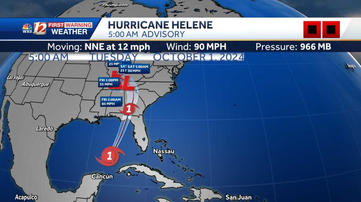
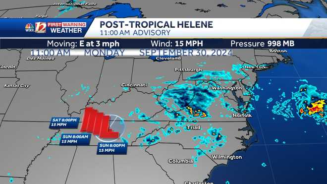
Wow. So of course, we want to bring in our meteorologist Dylan Heather and Brian Sloka making sure that everyone stays safe here at home prepared. Brian will kick things off here to share where the latest track of Helene is and time out what we’ll see throughout the next two days. *** couple of concerns with the storm out of the gate is the fact that we’re talking about *** land falling, major hurricane Florida, that’s gonna have *** lot of forward speed and momentum. Think about, uh, bowling as *** youngster when you’re throwing the ball down the lane, the ball doesn’t move very quickly. That’s how most tropical systems go. They might hit the pin and knock *** few down but not that many. Now, take *** bowling ball thrown by an adult, *** lot more momentum coming in. This is what AAA strong or major hurricane, uh, could produce, um, more of an impact on an inland area when it’s got some forward speed and it just doesn’t have the time to die down like it normally would, if it was moving slower, it’s picking up speed too north northeast, moving at about 12 MPH winds are now up to 90 with every advisory coming in the winds, either stay put or get *** little bit stronger. And we’re expecting 100 mile an hour winds in the not too distant future and potentially up to 115, 120 or even higher, uh, potentially by the time it makes landfall, uh, presentation pretty good. We do have some good rains now moving into Florida but notice how they extend beyond your banner and farther north. That is our concern is that we are getting good rains um, from tropical moisture that’s being fed in ahead of *** cold front and that’s bringing some torrential rains to our mountains even in advance *** day or two in advance of this storm coming in. Now, we’re expecting landfall. Now, *** national hurricane center with the latest advisory kind of backing off the cat four landfall and making it *** cat three, pushing it northward, weakening it and then kind of spinning it through northern Georgia and the Western Carolinas in the upstate region. So you bring in *** lot of moisture, pushing up slopes and along the frontal boundary. The rainfall rates for the next couple of days are gonna be very, very high and that lingering low will keep *** chance for some lighter showers in the forecast over the next couple of days. As we take *** look at the models. Uh, you can see the storm really starting to intensify, kind of tighten up and begin to come in. I’ve noticed in the last couple of runs that the models have been trending *** little bit farther east. That’s not *** good situation for us. It puts us closer to the greatest impact of this already. Even before landfall. Those rains extend farther north and bring torrential rains in our area. I think to try its main impact window from this will be tomorrow morning through midday and then should start to taper off after that. Uh Biggest issue in the west is gonna be flooding. Uh, high rainfall totals expected. Uh Dylan’s gonna get into that in just *** moment. Uh We do have flood watches posted for much of the area through eight o’clock on Friday. Temperatures concurrently are in the lower seventies. We don’t have *** lot of rain in the triad but the mountains already seeing *** lot of rain and we’ll see more highs in the sixties there breezes won’t pick up until later on tonight. Southeast winds at 8 to 15 for the foothills or high temperatures. Also in the mid seventies day, similar winds, high rain chances, Wilkes County uh into Surrey County could see some high rainfall totals there as well. Uh For the triad again, rain chances gradually increasing to impact levels later on, but we’re gonna start out much slower than our western counties. More of *** spotty shower chance coming in. But look at the persistence of the rains farther west, we’ll have *** few bands of some heavy thunderstorms coming in and then this starts to really get going early tomorrow morning. And you can see that we have some heavy rainfall and embedded in these bands around the center of that storm. There’s *** good chance we could see rotating thunderstorms and the chance for tornadoes. So that’s how the models are shaping up. This should begin to wind down midday or early afternoon tomorrow, Dylan bring us home. What are the impacts for our localized areas? That’s right, Brian. Yeah, I’ve got you. II I think this storm is gonna be pretty nasty. You mentioned, it’s got *** lot of forward speed. We’re on that right side, that eastern flank of the storm, which is usually where the worst weather is found. So this will likely be fairly impactful. Power outages are something we’re gonna be concerned about across the entire area tomorrow morning, especially as those nas nasty outer rain bands are moving through probably 7 to 11 o’clock, *** big time frame for some wind rain storms, maybe even isolated, spin up tornadoes. And so let’s bring you home here and put *** bow on it, wrap you up with *** summary of what to expect starting off with the mountains. Now, through midday tomorrow, we’re expecting 5 to 10 inches of rain on top of what you’re getting and what you’ve already gotten. So that’ll cause significant flash flooding, some river flooding, possibly as well, 35 to maybe 50 mile per hour wind gust down trees possible there in the foothills. 3 to 6 inches of rain, flash flooding possible with some 30 to 40 mile per hour gusts and in the Piedmont Triad here, our main window will be Friday morning through midday. 1 to 3 inches of rain, we’ll keep you posted on any isolated spin up tornadoes. There’s your seven day things start to improve over the weekend. We’ll be right back.
Hurricane Helene to hit Florida as catastrophic major hurricane while tracking towards North Carolina
Hurricane Helene is expected to hit Florida Thursday as a major hurricane, bringing with it a 10-20 foot storm surge, before it barrels towards the Carolinas, where it will pack another punch. Those impacts could be significant in North Carolina. The latest models show it could make landfall as a major hurricane in the Big Bend area of Florida. Then it will continue to track toward the Southeast U.S. heading for the Carolinas. Hurricane Helene originally formed Wednesday as a Category 1 storm before strengthening. Helene will rapidly intensify while bringing hurricane-force winds and torrential rains even in the Carolinas. ►Get the latest severe weather alerts for your area here.What weather impact will Helene have in North Carolina? Currently, the state is under a State of Emergency while bracing yet again for another tropical system while still recovering from historic flooding just last week. More in-depth forecast including timing and impacts below for North Carolina but first the latest maps and models. Latest Helene Maps and ModelsHere’s a look at Helene’s trackHere’s a look at spaghetti models What impact will Helene have in North Carolina?Helene will bring tropical conditions to the Carolinas with the potential for heavy rain, flooding, hurricane-force winds, and tornado threats. In North Carolina, the storm could bring damaging winds and also flash flooding including intense flooding to the mountains, foothills, and also to the Piedmont Triad. The track and size of the storm will also mean changes to rainfall totals. Potential Rainfall GFS Model Potential Rainfall EURO Model Helene will ramp up in North Carolina late Thursday night into early Friday morning with impacts still being felt in the afternoon. ►Latest maps, models, active alerts, forecast, live radar, evacuations, shelters, skycams Tropical Storm Watch for parts of North CarolinaTropical storm watches have also been issued for parts of North Carolina.Keep up with the latest news and weather by downloading the WXII app here.Stay with WXII 12 News for continued tropical storm and severe weather updates. HURRICANE RELATED COVERAGEMore weather coverage: Weather Alerts | Closing and delays | Latest weather forecast | Post pictures to the uLocal North Carolina Facebook Group | Traffic information | Report closings and delays | SkyCams | Download the WXII12 News mobile app►Download the Very Local app for storm updates.
Hurricane Helene is expected to hit Florida Thursday as a major hurricane, bringing with it a 10-20 foot storm surge, before it barrels towards the Carolinas, where it will pack another punch. Those impacts could be significant in North Carolina.
The latest models show it could make landfall as a major hurricane in the Big Bend area of Florida. Then it will continue to track toward the Southeast U.S. heading for the Carolinas. Hurricane Helene originally formed Wednesday as a Category 1 storm before strengthening. Helene will rapidly intensify while bringing hurricane-force winds and torrential rains even in the Carolinas.
►Get the latest severe weather alerts for your area here.
What weather impact will Helene have in North Carolina? Currently, the state is under a State of Emergency while bracing yet again for another tropical system while still recovering from historic flooding just last week.
More in-depth forecast including timing and impacts below for North Carolina but first the latest maps and models.
Latest Helene Maps and Models
Here’s a look at Helene’s track
Here’s a look at spaghetti models
What impact will Helene have in North Carolina?
Helene will bring tropical conditions to the Carolinas with the potential for heavy rain, flooding, hurricane-force winds, and tornado threats.
In North Carolina, the storm could bring damaging winds and also flash flooding including intense flooding to the mountains, foothills, and also to the Piedmont Triad. The track and size of the storm will also mean changes to rainfall totals.
Potential Rainfall GFS Model
Potential Rainfall EURO Model
Helene will ramp up in North Carolina late Thursday night into early Friday morning with impacts still being felt in the afternoon.
►Latest maps, models, active alerts, forecast, live radar, evacuations, shelters, skycams
Tropical Storm Watch for parts of North Carolina
Tropical storm watches have also been issued for parts of North Carolina.
Keep up with the latest news and weather by downloading the WXII app here.
Stay with WXII 12 News for continued tropical storm and severe weather updates.
More weather coverage: Weather Alerts | Closing and delays | Latest weather forecast | Post pictures to the uLocal North Carolina Facebook Group | Traffic information | Report closings and delays | SkyCams | Download the WXII12 News mobile app
►Download the Very Local app for storm updates.


