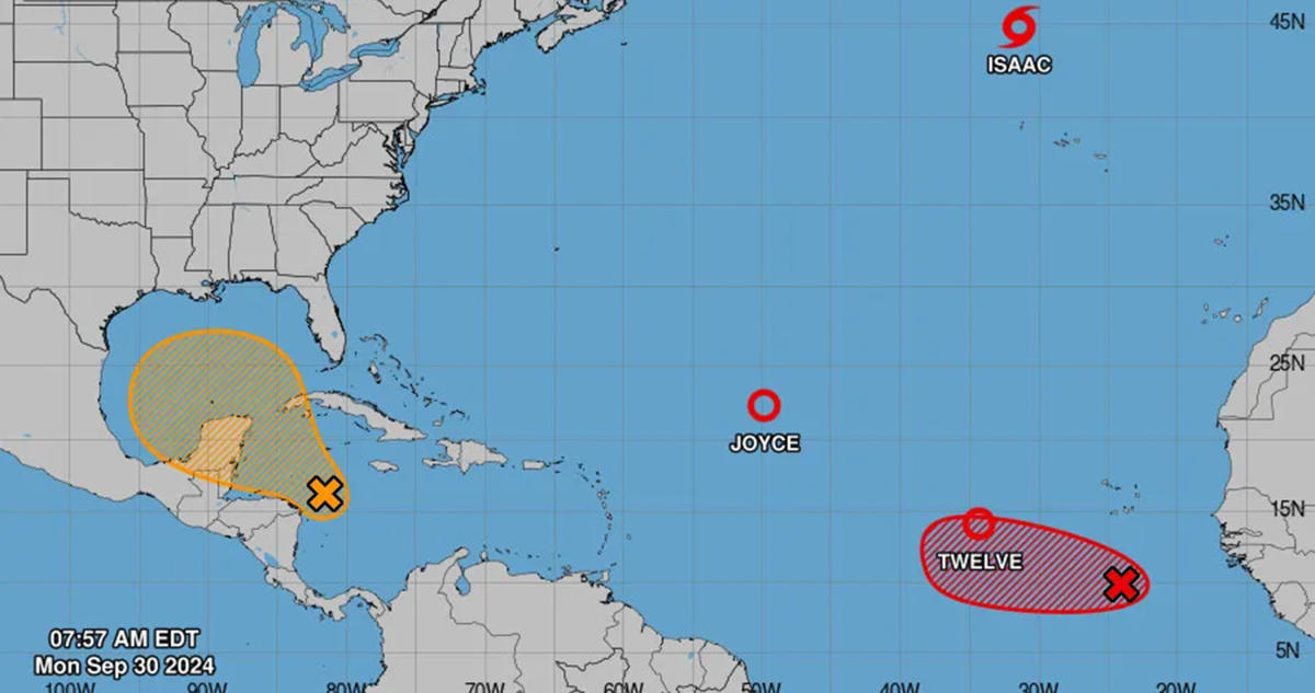
ORLANDO, Fla. — The National Hurricane Center was busy Monday tracking newly formed Tropical Storm Kirk, as well as what remains of Tropical Depression Joyce and Post-Tropical Cyclone Isaac in the Atlantic while also monitoring two more systems with the potential to become the season’s next tropical depression or storm.
As of the NHC’s 2 p.m. EDT tropical outlook, the biggest threat to Florida could be a trough of low pressure that has formed over the southwestern Caribbean Sea forecast to move into the Gulf of Mexico this week producing disorganized showers and thunderstorms.
“Environmental conditions could become conducive for gradual development, and a tropical depression could form in a few days while the system is over the southern Gulf of Mexico or northwestern Caribbean Sea,” forecasters said. “Interests along the U.S. Gulf Coast should continue to monitor the progress of this system.”
The NHC gives the system a 10% chance to develop in the next two day and 40% chance in the next seven days.
It’s the same region where Hurricane Helene began forming as a potential tropical cyclone, before sucking up all the energy of the warm Gulf waters ahead of its eventual landfall on the Big Bend region of Florida as a Category 4 hurricane.
Helene is being blamed for more than 100 deaths across six states having devastated Florida’s coastal communities with storm surge and wind impact, but causing even more destruction inland as its rains caused mudslides and flooding up into Georgia, Tennessee and North Carolina.
Just which part of the Gulf Coast the system could target is up in the air, but if it were to develop into a hurricane and strike the U.S., it would fall one shy of the record for most hurricanes to do that in a single year with five, according to Colorado State University meteorologist Philip Klotzbach. That happened in 1882, which saw six on one year. Four or more have hit this year, and then 1909, 1985, 2005 and 2020 as well.
Elsewhere, the NHC was eyeing a tropical wave a few hundred miles south of the Cape Verde Islands with limited shower and thunderstorm activity.
“Upper-level winds appear conducive for further development, and a tropical depression is very likely to form in a few days while it moves slowly westward over the eastern tropical Atlantic,” forecasters said.
The NHC gives it a 50% chance to develop in the next two days and 90% in the next seven.
After Kirk, the next names on the 2024 Atlantic hurricane season list are Leslie and Milton.
On Sunday, the 2024 hurricane season saw the development of its 12th official tropical cyclone with the formation of Tropical Depression Twelve, which grew into Tropical Storm Kirk on Monday.
As of the NHC’s 11 a.m. advisory, it was located about 740 miles west-southwest of the Cape Verde Islands heading west at 12 mph with maximum sustained winds of 50 mph. Tropical-storm-force winds extend out 115 miles.
“A general westward to west-northwestward motion is expected to continue through Tuesday. A gradual turn to the northwest is forecast by
Wednesday,” forecasters said. “Kirk is likely to become a hurricane by tomorrow and could become a major hurricane by midweek.”
If it does, it would become the third major hurricane of the season, although no threat to land in the Atlantic.
Also no threat to land in the Atlantic are the diminishing systems of what had been Hurricane Isaac and Tropical Storm Joyce.
As of 11 a.m. now Post-Tropical Cyclone Isaac was located 480 miles north-northwest of the Azores moving east-northeast at 17 mph with maximum sustained winds of 60 mph. Tropical-storm-force winds extend out up to 185 miles
“A turn to the northeast is expected with a similar forward motion for the next several days,” forecasters said. “Gradual weakening is forecast over the next several days.”
As of 11 a.m., Tropical Depression Joyce was located about 940 miles east-northeast of the northern Leeward Islands moving north at 2 mph with maximum sustained winds of 35 mph.
“A general northerly motion is expected for the next couple of days,” forecasters said. “Some weakening is forecast during the next 48 hours, and Joyce is expected to become a remnant low soon.”
Hurricane season runs from June 1-Nov. 30.


