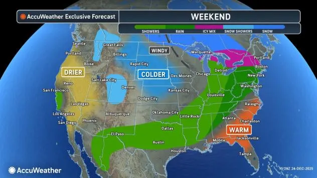
December has brought widespread cold to the Midwest and Northeast, and repeated bursts of Arctic air are likely to continue into the start of 2026.
After a quick-hitting storm spreads a swath of snow, sleet and freezing rain across the Great Lakes and Northeast Friday and Friday night, cold air will hold firm across New England and the central Appalachians this weekend. Meanwhile, warmer air will try to gain some ground in the East ahead of an approaching cold front.
The clash between the two air masses will result in spotty ice breaking out on Sunday near the central Appalachians in Pennsylvania to the Adirondacks in Upstate New York. The ice is not expected to be as long of a duration as what is forecast to end the week across portions of the mid-Atlantic, but it could still be enough to cause slippery conditions on untreated roads and sidewalks prior to a changeover to rain.

AccuWeather.com
Areas along the Interstate-95 corridor from Washington, D.C., to Boston can expect mostly rain from the late weekend event. Motorists traveling to the north and west suburbs of Boston and New York City may encounter some ice.
“Cold air will follow the strong cold front along with gusty winds and lake-effect snow and flurries across the Great Lakes, Ohio Valley and interior Northeast later Sunday into Monday,” AccuWeather Lead Long-Range Expert Paul Pastelok said.
Extreme cold returns after brief reprieve
High temperatures could drop more than 30 degrees Fahrenheit over the 24-hour time period from Sunday to Monday with the greatest plunge in temperatures expected over the Ohio Valley. In Indianapolis, for example, Monday’s high is expected to be in the middle 20s, following near-record warmth in the low 60s on Sunday.
Have the app? Unlock AccuWeather Alerts™ with Premium+
Daytime temperatures in the 20s and 30s will be common throughout the Northeast by Tuesday with teens and single-digits expected across the Upper Midwest. Factoring in a cold wind, AccuWeather RealFeel® Temperatures could be 20 degrees lower than a thermometer reading.
Snow showers and squalls will reduce visibility and can create slippery conditions for motorists across the Great Lakes and interior Northeast behind the front early next week.

AccuWeather.com
A reinforcing burst of Arctic air is expected to plunge southeas from Canada and into the Northeast right around the flip of the calendar to 2026.
“Into early January, the coldest air will be across western Canada, but colder air masses can occasionally be pulled south behind storms in the Rockies and Plains, then into the East briefly,” Pastelok said.
Want next-level safety, ad-free? Unlock advanced, hyperlocal severe weather alerts when you subscribe to Premium+ on the AccuWeather app. AccuWeather Alerts™ are prompted by our expert meteorologists who monitor and analyze dangerous weather risks 24/7 to keep you and your family safer.