The Bay Area is in for a weather reset this week, with chances of light rain Monday giving way to breezy winds midweek before a weekend warmup.
After a spell of record warmth to close February, March began with cooler weather Sunday, with morning fog and areas of drizzle in the coastal hills. A repeat is expected Monday morning, but drizzle and showers will probably be more numerous, with chances of pop-up showers over the interior mountains in the afternoon. Another chance of rain will come Wednesday, though showers will probably remain north of the Golden Gate.
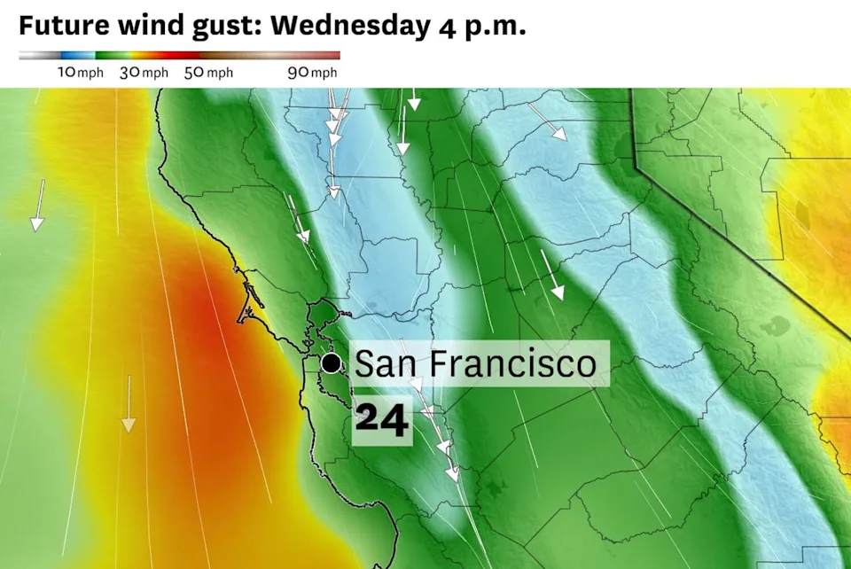
Winds will be the most pronounced weather impact for the rest of the week.

Northwest winds Wednesday are predicted to gust up to 35 mph before turning northeasterly Thursday and Friday. (Baron/Lynx)
A moderate northwest breeze is predicted Wednesday afternoon, with gusts potentially up to 35 mph along the coast and in the hills. Winds will turn north-northeasterly Thursday and peak Friday, with similar speeds possible in the hills.
Those northeast winds, known as Diablo winds, are drying, warming winds that can present fire danger, but are unlikely to cause major problems this week.

Bay Area temperatures are forecast to reach the upper 60s to mid-70s on Friday. (Baron/Lynx)
High temperatures are forecast to be in the 60s through Wednesday, but a few 70-degree readings are possible by Thursday. Most areas will climb to the 70s by Friday. Warmer-than-normal weather is likely to stick around through the weekend into the following week with no storms in sight through mid-March.
Monday breakdown
San Francisco: Drizzle will dot the hills in the morning with intermittent light showers elsewhere. It’ll hardly be described as rain, with no more than a minor inconvenience for the morning commute. Skies will brighten midday with temperatures climbing to the low to mid-50s. Light winds out of the northwest may gust up to 15 mph in the afternoon. Overnight lows will be around 50 degrees with patchy fog.
North Bay: Light rain is most likely in Sonoma and Marin counties through 9 a.m. before clouds begin to clear. Isolated showers cannot be ruled out in the afternoon as clouds bubble over the mountains. A few showers may drift off the hills toward the valleys, but most cities will stay dry. Highs will be in the low to mid-60s with light and variable winds. It’ll be cooler than recent nights, with temperatures dropping to the mid-40s.
East Bay: Morning showers should be confined to the Berkeley and Oakland hills and points westward, with Richmond and Berkeley having the best chance of a few hundredths of an inch. East of the Caldecott Tunnel, there should only be increased cloud cover, with no morning drizzle. In the afternoon, clouds building over the hills may produce a short-lived rain shower that drifts toward the Tri-Valley. Highs will be in the mid-60s across the East Bay, with lows in the mid- to upper 40s.
Pacific Coast and Peninsula: Drizzle is expected in Daly City, Pacifica and Half Moon Bay through about 10 a.m., then skies should clear for a partly to mostly sunny afternoon. Highs will be in the low 60s. The Highway 101 and Interstate 280 corridors will probably stay mostly dry, though a rogue shower cannot be ruled out in the morning, especially around San Bruno and South San Francisco. Highs will be in the low 60s in those cities and mid-60s in San Mateo and Redwood City. Lows will be in the upper 40s to low 50s.
South Bay and Santa Cruz: The South Bay will probably miss out on the fizzling line of morning rain showers, but the afternoon may present another window of opportunity. Clouds developing over the hills are expected to drop short-lived rain showers, which could drift over Boulder Creek, Morgan Hill, Santa Cruz, Los Gatos and other communities in the foothills. Most areas will be dry, though. Highs will be in the mid-60s, with lows in the mid- to upper 40s.
This article originally published at From drizzle to Diablo winds: Here’s how the Bay Area forecast flips this week.