
Good Saturday, Everyone! The DC NewsNow weather team has issued another DMV first warning for the area, effective through Sunday afternoon and evening, and into Monday morning. More snow is on the way, with the greatest accumulation occurring further north and east of D.C.
Tonight will be quiet, with just increasing clouds through midnight, but after midnight and around sunrise, light to steady rain showers will overspread the DMV, except in the mountains. Expect overnight lows to hold in the 30s everywhere, but as you go higher, you’ll see closer to freezing temperatures.

Sunday, our next winter storm develops, and this time around, the setup will be different. For starters, this storm will begin as rain across the region, except for the Allegany Front area in Garrett and Western Allegany Counties in Maryland. Precipitation is expected to develop from west to east across the region late tonight and into early Sunday morning. The wet weather is forecast to start as a mixture of light rain and snow for most, with all snow above around 1500 feet. The key to this storm, as with many past storms, is the temperature profile the atmosphere initially establishes.

Most areas will start in the mid to upper 30s, and look to hold in the mid 30s through mid-afternoon. As a result, much of the DMV will see several hours of either just plain rain or a mix of rain and snow. So for starters, the initial moisture doesn’t really accumulate and will largely be unimpactful other than making the roads wet. At higher elevations, however, snow will accumulate throughout the day.

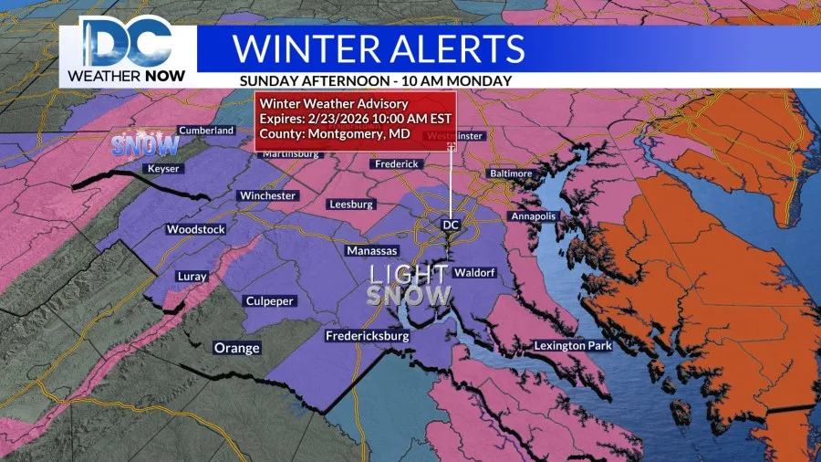
By late afternoon and evening, temperatures start to fall as the storm off our coast pulls in colder air. This will help convert any rain to snow for the remainder of the day and into the night. It is at this time that we see snow accumulate everywhere in the DMV. Two distinct bands of enhanced snowfall rates are possible: the first near the Chesapeake Bay and the second in the Cumberland Valley. This is also why the Winter Storm Warning wraps around the DC Metro area.


Across the entire DMV, snow totals will be dependent on elevation, so in terms of specific snow amounts, a general 2-4 inches is expected in and around the Beltway, 4-6 inches across northern Montgomery County and points north of there, with higher amounts around the Chesapeake and along the Blue Ridge and Allegany mountains where it will linger the longest.

By Monday night and heading into Tuesday, the region will be dry, but also cold, as the thermometer will remain below normal. Tuesday night into Wednesday morning, a fast-moving storm will move into the DMV, bringing mainly a chilly rain, but some more snow for the mountains. Behind this quick system, a southerly wind direction will allow milder air to return after a rapid chilldown. With temperatures rising into the mid-40s to lower 50s Wednesday through the rest of the work week, our next storm will be all rain. This looks to occur on Thursday under cloudy skies. On Friday, the storm system and its cold front will exit the area, and drier weather will take over through next weekend.

Copyright 2026 Nexstar Media, Inc. All rights reserved. This material may not be published, broadcast, rewritten, or redistributed.