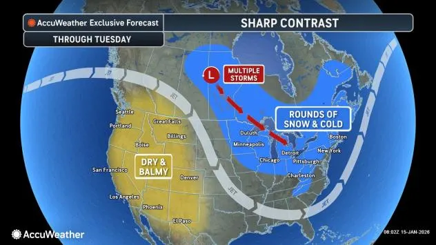
A cold-weather setup will take hold across the north-central and eastern United States through the end of the month with few interruptions. Clipper storms will ride along in the waves of cold air, producing rounds of light snow, heavier squalls and bands of very heavy lake-effect snow. Regardless of the amount of snow, roads will be slippery where snow falls.
Several crashes have been reported across the region earlier this week amid blustery snow showers, including a 30-vehicle pileup on Interstate 90 near Elkhart, Indiana, on Wednesday, and another multi-vehicle crash on Interstate 80 in western Pennsylvania on Thursday.

AccuWeather.com
“Back-to-back rounds of wintry weather will bring snow to the interior Northeast and Great Lakes,” AccuWeather Meteorologist Brandon Buckingham said. “A foot or more of snow could pile up in areas downwind of the Great Lakes and across higher elevations by the end of the weekend.”
One clipper storm will finish up in the Northeast on Thursday night. However, the next clipper storm, with its snow, is already moving southeastward over the Upper Midwest.

AccuWeather.com
With this clipper storm, snowfall in most areas will be light, generally ranging from a coating to a couple of inches.
There will be some locations along the northern tier where moderate snowfall of 3-6 inches is expected. Areas along the Michigan shoreline of the Lower Peninsula of Michigan will also pick up fresh snowfall.

AccuWeather.com
In the wake of this clipper storm, the lake-effect snow machine will resume.
“Road conditions can deteriorate rapidly when snow bands move through,” Buckingham said. “Drivers should slow down and increase following distance. Sudden drops in visibility and slippery roads are a dangerous combination.”

AccuWeather.com
Some of the heaviest lake-effect snow from Friday night to Saturday night will fall along the Michigan shoreline of Lake Michigan and in portions of western and northern New York state.
“Snow accumulations are possible in the Poconos, Catskills, and Berkshires this weekend as well,” Buckingham said.

AccuWeather.com
Rain and snow showers are forecast to extend from northeastern Maryland to southeastern Maine on Saturday, including in the metro areas of Philadelphia, New York City and Boston. While these will generally not accumulate in the heart of urban areas, outlying locations could pick up a brief coating of snow if it snows hard for a few minutes.
GET THE FREE ACCUWEATHER APP
•Have the app? Unlock AccuWeather Alerts™ with Premium+
The conditions may be wintry enough to prompt aircraft deicing operations, which can delay flights. Much more snowy conditions are in store for Pittsburgh, Detroit and Chicago on Saturday, relative to the Interstate 95 corridor.
As if one clipper storm was not enough, yet another Canadian storm is forecast to drop southeastward on Sunday over the Great Lakes region.

AccuWeather.com
Most of the moisture and the corresponding snow with this storm will be a bit farther north than its predecessors, but it will still manage to bring enough snow to create slippery conditions as far south as Chicago and Detroit later Sunday and Sunday night.
The clipper storms will stir up the atmosphere enough to create episodes of gusty winds. The combination of wind and cold will make it difficult to be outdoors for extended periods. Winds could be strong enough to affect lift operations at some resorts for a brief time.
Meanwhile, along the Atlantic coast, a southern storm will be watched for a possible close encounter with the Northeast. The most likely scenario is for the storm and its snow to avoid the Interstate 95 Corridor, but there is still a chance the storm and its snow shift farther west at the last minute on Sunday night.
Want next-level safety, ad-free? Unlock advanced, hyperlocal severe weather alerts when you subscribe to Premium+ on the AccuWeather app. AccuWeather Alerts™ are prompted by our expert meteorologists who monitor and analyze dangerous weather risks 24/7 to keep you and your family safer.